
➞ This just one of the places we went on the South Pacific trip we took in December 2018.
Situated in the Southern Hemisphere near the International Date Line, American Samoa is home to the most far-flung National Park in the United States.
And as a result, it was on our itinerary to visit as part of my national parks quest.

The national park straddles all three of American Samoa’s main islands, though we would only get a chance to visit Tutuila, its largest. That’s because the Manu’a Islands—which feature Ofu Beach, one of the most gorgeous you’ll find anywhere—are considerably more difficult to reach for the time-constrained traveler, as transportation options are both limited and notoriously unreliable. That wouldn’t work for us this trip, but it gives us a good reason to go back (as does our experience at Tisa’s Barefoot Bar).

Oh, the mountains!
One of the most striking things about American Samoa is its mountains. These mountains feature daunting slopes and are blanketed with lush rainforest vegetation. It’s really incredible—nearly every square foot is thick green, even at angles where it seems unlikely that plants could grow in such abundance.
These mountains are the primary feature of the national park lands here, along with the beaches and a swath of ocean and coral they spill into. As a result, there are few maintained trails to choose from, only two of which were open during our visit.


These mountains and ridge lines run the length of Tutuila, dominating the skyline no matter where you find yourself on the island. Given their incredible slope, this spine creates a rather formidable barrier.
In fact, just a handful of roads cross the mountains, connecting a few otherwise isolated villages with the main highway that skirts the island’s southern edge. These steep roads often requiring downshifting just to make it up to the pass. Along these narrow and winding roads, the lush vegetation only occasionally opens up for a clear view down the hillside.

Looking across Āfono Bay from Lower Sauma Ridge. 
Looking down at the village of Fagasā from Fagasā Pass.
Most of the population lives and works along this main highway, with the bulk in the Tafuna region, the only extended flat area of the island. Beyond this area, nearly every building you’ll encounter is either located on the main highway or off a small spur road from the highway. As a result, touring the island is a wonderfully intimate experience.
And as you can see from the photos below, most vistas feature a line of buildings at sea level, with mountain slopes towering behind them.

Matafao Peak looms behind Pago Pago Harbor 
Rainmaker Mountain 
Looking across Pago Pago Harbor 
The beach at Vatia Bay


Looking for some snorkeling
After an annoying three hour delay in getting our rental car—be prepared for “island time” if you visit—we went straight to the National Park visitor center. Located on the second level of a storefront in Pago Pago, it’s small but basically what you’d expect: some nice displays, an information desk, and a passport stamp.
Because we had arrived without much of an itinerary, we had hoped that we’d be able to glean some good recommendations on where to snorkel—one of our favorite trip activities—but the volunteer struggled to give any solid suggestions.
We had a similar experience the next day at the Ocean Center, which manages the national marine sanctuaries. It was a bit surprising, since that seemed to be one of the big things to do here. Luckily, the coral reefs are shown on the park map and you can easily spot many of them while driving around.
Unfortunately, you might also spot one of these signs at some of your intended destinations:

Hmmm. Maybe we won’t be doing much snorkeling here after all…
Undeterred, we decided that we’d spend most of our time exploring the island by car. First up was visiting the national park, the primary reason for our trip, along with the rest of the eastern end of the island.
National Park of American Samoa
We had arrived knowing that, comparatively speaking, there weren’t many activities to do in this park. After all, at a mere 13,500 total acres, it’s one of the smallest national parks in the system. And much of the park acreage is either rugged, mountainous terrain with only a few developed trails, or shallow waters with fringing coral reefs.
But more than any other, this national park is as much about what you do outside the park boundaries as what you do within them.
The park newspaper and other materials make this quite clear—the majority of the information presented focuses on the islands as a whole, not simply about what to expect within the park boundaries. In addition to the stunning landscape, this park is about experiencing all of American Samoa, including fa’asamoa, or the “Samoa way of life.”
Nonetheless, we wouldn’t come all this way without spending some time enjoying the national park itself.

It didn’t take long to find the entrance sign that’d serve as the customary backdrop for my park unit number photo. And a while later, we found ourselves at the end of the road in the village of Vatia. There, we’d enjoy our favorite part of our national park visit: a short trail to a cobblestone beach overlooking the incredibly scenic Pola Island and the Vai’ava Strait National Natural Landmark.

The best way to experience the island
While we enjoyed the sections of the national park we visited, the real highlight was simply exploring the island by car. And that’s mostly what we did, driving virtually every stretch of roadway we could.

Unlike other nearby destinations, such as Fiji, there’s not a lot of tourist infrastructure in American Samoa. There are just a handful of hotels, relatively few restaurants, and little else geared towards visitors. That means you’ll mostly be on your own for things like sightseeing and snorkeling.
While there are a number of informal pull-offs along the roadway, there definitely aren’t enough for all the great views you’ll encounter. Luckily, driving here is quite slow, so you won’t feel too rushed as you pass vista after vista that belong on postcards.
If you’re tempted to stop in villages, be sure to adhere to the local cultural norms. That means asking locals for permission before taking photos, using a beach, or parking—even if it seems otherwise unobtrusive. You’ll nearly always be granted permission.


Some things you’ll notice
Fales
As you travel across the island, you’ll likely notice that much of Samoan life takes place outdoors. Given the tropical climate, that shouldn’t be unexpected. Indeed, it’s impossible not to notice that most homes feature some variety of fale—an open air, pagoda-like structure with pillars and a roof that serves as a primary place of activity. Some of these are used as actual living quarters, while others are used for entertaining guests or conducting traditional ceremonies. Beach fales, which resemble smaller huts, are also common throughout the island.

Family graves in the front yard
If you’re touring the countryside by car, you’ll also likely notice a marble gravesite or two in front of a number of homes. For those of us who grew up in a place like the United States, that seems especially weird—after all, it’s hard to sell a house with your grandfather prominently buried near the front door.
But the concept of land ownership is much different here. It’s communal, and families stick around. Samoan custom prevents real estate sales to outsiders; even the National Park itself could only be negotiated as a 50 year lease with several local villages.
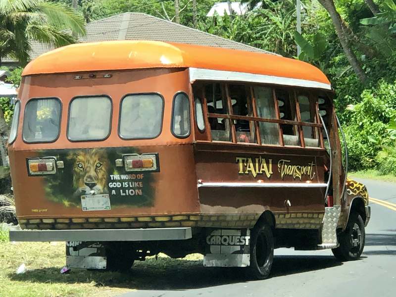
Aiga (family-run buses)
Colorful small shuttle buses, called aiga, are found throughout the island. These family-run enterprises can be hailed nearly anywhere and charge a small fee for transporting you to any other spot along its route. Most seem to originate at the market near the national park visitor center. While this seems like a convenient method of transportation, we preferred the comfort and flexibility of having our own rental vehicle.
Stray dogs and ugly trash
When you take a trip to a South Pacific island, you may be expecting a pristine and idyllic setting. But if you’ve visited remote tropical islands before, you know that’s not the full picture. While beautiful, there are real problems here, too.
One of those problems seems to be litter, which is omnipresent along many of the roadsides and on a number of the beaches. It’s not always clear where all the litter originated—some of the beach trash may have washed up on shore from distant sources. But a fair amount seems to be generated on the island itself, as noted by an anti-littering ad campaign we noticed plastered around the island.

Island life tends to be a simpler life, but it usually means a less affluent one, too. While generally cared for, many buildings were showing serious signs of deterioration. Some were clearly damaged in previous cyclones or tsunamis, while others just seemed to have been abandoned ages ago. Freshly painted or recently built structures sometimes seemed a bit out of place here.
Outside of what you might consider the urban core, feral dogs roam around nearly every village. Sometimes they absentmindedly block the road. Other times, they bark furiously at strangers. But most of the time they simply go about their own business eeking out a living by scavenging for food. We noticed several dogs living with bad injuries, such as an obviously broken leg.

Notably, the National Park Service makes a point to warn visitors about potentially “unfriendly” dogs in their visitor guides and other handouts.
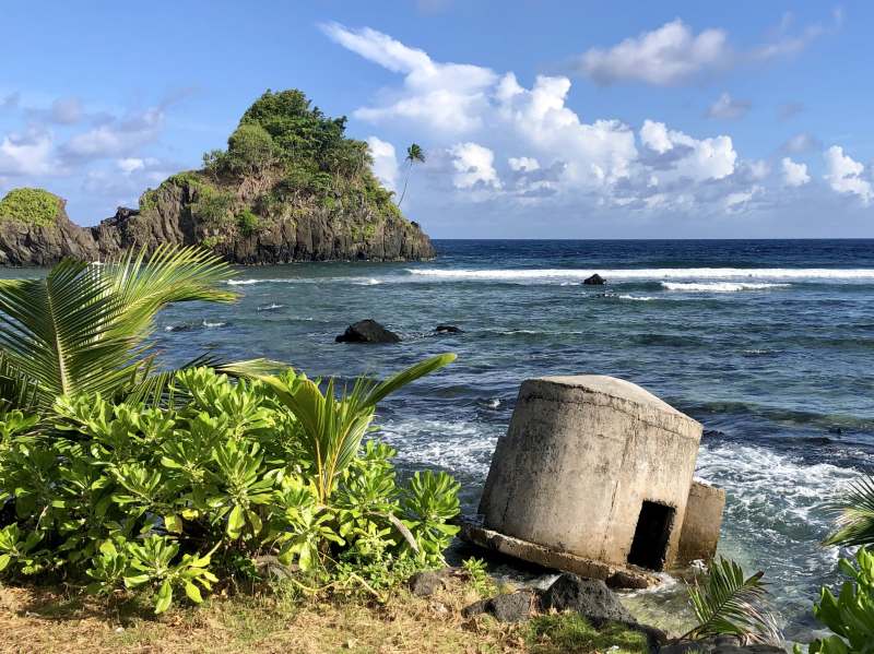
Shipwrecks
There are a few shipwrecks around the island, and they’re all well-placed for photos. It doesn’t seem like this is prime shipwreck territory, but it must be hard to find a more scenic spot to run aground.


The Starkist Cannery
American Samoa’s largest private employer—by a wide margin—is Starkist. It’s impossible to miss the tuna canning plant on the north edge of Pago Pago Harbor. When you pass by, note the workers wearing different colored shirts, presumably to delineate their job functions. You’ll also notice the industrial port across the harbor, which ruined several otherwise gorgeous photo ops.
Pillboxes and other remnants of WWII
While fighting never reached the island during World War II, there are a number of defenses that still remain here. For instance, several WWII-era concrete guardhouses, often called pillboxes, line the shoreline of Tutuila. Two short trails also lead to gun batteries high above both Blunts Point and Breakers Point.
National Natural Landmarks
American Samoa is home to to seven National Natural Landmarks (or NNLs), many of which are prominent features of the island. While these designations are intended to acknowledge important geological resources, NNL status does not provide any special protections.
Few “perfect” beaches
While the island certainly has its share of scenic beaches, many are relatively small and most are pocked with black lava rock. As a result, this isn’t a place were you see hoards of swimmers and sunbathers lining every stretch of sandy coastline.


Completing two quests
With our visit to American Samoa, we were able to complete two quests. This was the last territory we needed in our quest to visit all 50 States and all 5 major US Territories, which currently ranks as the biggest travel quest I’ve completed. And during our travels to those territories, we made a special point to visit every local craft brewery in each, too.

The biggest quest I’ve completed. 
Cheers to finishing another quest!
There wasn’t a craft brewery currently open in American Samoa, but one was getting close to opening—Flying Fox Brewing. So we got in touch with the brewer, Nate. He loved our quest and graciously offered a private tasting for us. We enjoyed both the brews and our conversations about the challenges he faces in running a brewery in such a far-flung place dominated by a few mass-produced island lagers. Unfortunately, this was pretty much the only good beer we had the entire trip.


Random factoids
- The Samoa Islands are believed to be the ancestral home of the Polynesian culture.
- About 30% of local plants are found nowhere else.
- American Samoa is the only US Territory south of the Equator.
- Two species of flying fox (fruit bat) have 3-foot wingspans and are the only mammals native to the islands.
- Over 250 species of coral occur locally and help support nearly 1,000 species of fish.
- American Samoa features the only paleotropic (Old World) rainforest in the US.
- Pago Pago Harbor, a collapsed volcanic caldera, is one of the largest natural harbors in the South Pacific.
- Some of the tallest sea cliffs in the world can be found on the island of Ta’ū.


With more time, we would have…
As always, time and money served as a big limiting factor for this trip. Given our other travel goals, available time off, and budget, we knew that this would be a shorter visit than we would have preferred. In particular, we were bummed that we couldn’t make it to the Manu’a Islands, especially Ofu. We’ll definitely need to return in the future.
The best snorkeling in the national parks is Ofu in American Samoa.
NPS Director Jon Jarvis explained to me in 2016.
Had we scheduled more days to spend on Tutuila, we would have spent it snorkeling at Fagatele Bay and exploring the dense rainforest in more detail on a longer dayhike, likely on the Tuafanua or Lower Sauma Ridge trails. We also would have spent a few hours out at ‘Aunu’u Island and driven up to A’oloaufou to see the view. And, of course, we would have returned again to Tisa’s, and also checked out Two Dollar Beach further down the road.
Nonetheless, we had a truly excellent time, and we’re glad we didn’t postpone the trip for some unknown opportunity when time and money allowed for a longer visit.

Some additional tips
If you’re planning a visit, here are some tips that might prove helpful.
- We arrived in American Samoa via a small commuter plane from the tiny Fagali’i Airport in (Western) Samoa using Talofa Airlines.
- We stayed at Sadie’s by the Sea, which seems like the best choice.
- American Samoa is just half the story of the Samoa Islands—make sure you spend some time in (Western) Samoa, too. While both places share a common language and culture, they’re distinct places and your experience will be different.
- Hearing numerous warnings about mosquitos and the risk of dengue fever, we came prepared. We pretreated all of our clothes with Permethrin, packed long-sleeved shirts and lightweight pants, and brought lots of insect repellent. It was mostly for naught—we hardly saw a mosquito.
- If you’re planning on snorkeling, bring your own gear or arrange to rent it ahead of time.
- Keep your eye out for swimming advisory signs before you get in the water. If the sign is shaped like a triangle, the water is deemed safe; if it’s shaped like a diamond, then it’s not.
- As far as we could tell, Fagatele Bay National Marine Sanctuary, Cononut Point, Alega Bay, and the reef area between Fatu Rock and Faga’alu offer the best snorkeling options on Tutuila—but sadly, we weren’t able to personally verify any of them.
- English is widely spoken.
- American Samoa uses US Dollars.
- Tipping is not expected or customary.
- Vehicles use the right side of the road, but drivers behave a bit differently here than in cities back on the mainland. Slow down and pay attention to the roadway. You’ll also need an international drivers license.
- Sunday is for church, rest, and quiet—so some activities, like swimming, may not be allowed. We scheduled the trip to avoid this.
- Each evening around dusk, villagers observe a time for prayers called Sā. If you are entering a village during Sā, stop and wait quietly until Sā ends. You may even be invited to join in a family prayer. It is not necessary to stop for Sā on the main roads.
- Even while swimming, wear modest clothing—no bikinis.
- The wetter season is October to May, which also coincides with cyclone season.


More photos coming
I haven’t had a chance to review and edit all the photos we took during our time in American Samoa, so I’ll likely update this with more pics in the coming weeks. In the meanwhile, you can find more photos of our trip at this Flickr album.
Great photos! Looks and sounds similar to (Western) Samoa. Definitely worth a visit, but not a super long one…
Informative post! Where was the NP sign? Near the Visitor Center or on the road to Vatia? Thank you for helping us plan our visit!
marianne
There is a sign at visitor’s center (along with a vertical flag), but the main “entrance sign” was along the road to Vatia near where the roadside interpretative signs are. You can’t miss it.